This resource comes from the Library of Congress, which is a giant site we love. I came across the map when I was on the Teaching with Primary Sources Network (another site we love) and one of the members recommended it to me. This site is a great cross-curricular resource and it will appeal even to your students who don’t like poetry. Confession: That’s me. Sorry, English teachers but I have never liked poetry. (Hey, if English teachers can say they don’t like math, I can say I don’t like poetry.)
Living Nations, Living Words – A poetry site even students who hate poetry will love
The site opens with an article by Joy Harjo , a name that even I, definitely not a poetry lover, recognize and respect. Having been the poet laureate of the United States, it’s no surprise that her words draw you in.
The very first maps were drawn into the earth with stick or stone implements. They told us where we lived, the location of food, water, and danger.
– Joy Harjo
Showing the location of each poet on a map teaches students both about the geography of the U.S. and the Indigenous people who lived in each area. The brief biography of each poet provides successful role models who have not only published books of poetry but been bronc riders (Henry Real Bird) , published novels and own a bookstore (Louise Erdrich) and earned an Emmy (M. L. Smoker).
A Good Lesson Makes the Student Ask Questions
Hopefully, we have all had that experience where students get excited about a lesson. They started talking over each other, practically jumping out of their seat with a question they HAVE TO ask. This lesson brought up a few questions from me, including wondering whether students who are not interested in math or science would be ‘hooked in’ by the connection with poetry, poets or Indigenous culture. For example,
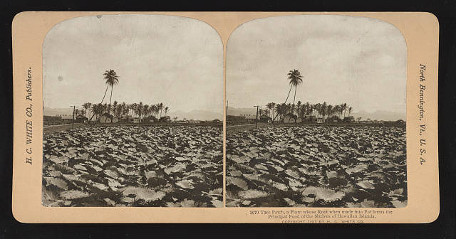
Interwoven in the poem is the story of Hāloanakalaukapalili (or Hāloa Naka), the taro plant. Hāloa Naka, child of Papa (Earth Mother) and Wākea (Sky Father), was stillborn. He was buried, his mother’s tears at the grave nurturing growth of the first kalo plant, which became our traditional staple food.
– Mahealani Perez-Wendt
I also downloaded the dataset from the site and wanted to use the X and Y coordinate positions to teach students about coordinates but unless I am missing something, and I may be, it appears you need to learn ArcGIS and have paid a $500 annual membership to use these coordinates. If anyone knows any more about that, please enlighten me. I did email the LOC library help desk and they are usually super helpful and prompt, so when I learn more, I will update this post.